
Moroccan Kasbahs Architecture, and Rich History

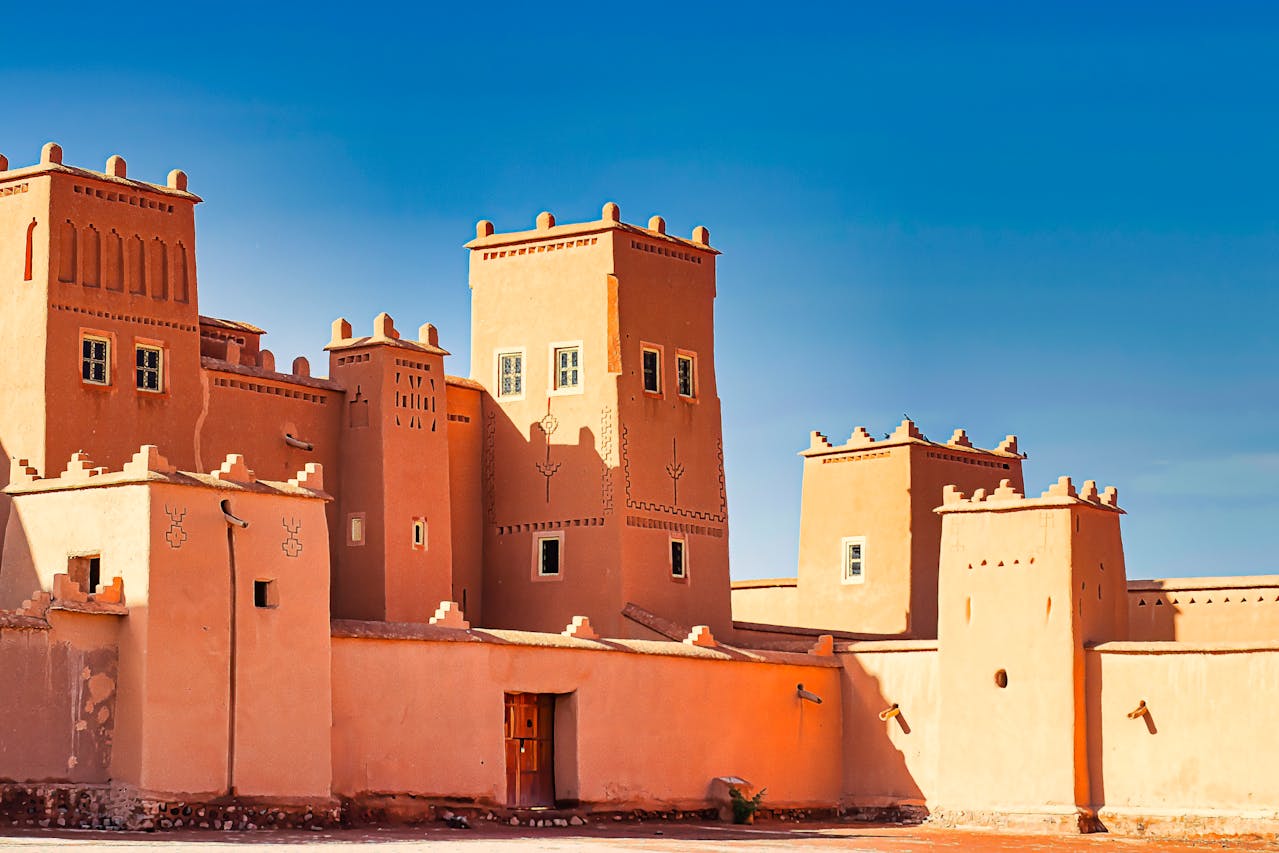
Moroccan Kasbah Architecture, Materials, Techniques and History The study of Moroccan kasbahs architecture reveals a deep connection between environment, society, and construction techniques. Kasbahs are not simply buildings. They are systems shaped by climate, local materials, and historical needs. These structures appear mostly in southern Morocco, especially in pre-Saharan regions, where communities adapted to harsh conditions through intelligent design. Unlike monumental stone architecture found in imperial cities, kasbahs rely on earth. Builders used what the land provided. They transformed soil into walls, palm trunks into roofs, and geometry into defense. This architecture reflects a balance between function and environment. It also reflects social organization, where power, protection, and trade intersect. To understand kasbahs, one must examine how they are built, where they exist, and why they played such an important role in Moroccan history. What Is a Kasbah? A kasbah is a fortified residence, often associated with local leaders or powerful families. It differs from a ksar, which refers to a fortified village. While ksour group multiple families within defensive walls, kasbahs usually serve as private strongholds or administrative centers. These structures often rise above surrounding landscapes. They stand near oases, valleys, or strategic routes. Their placement allows control over movement, resources, and trade. In many regions, kasbahs acted as both homes and symbols of authority. Construction Materials: Building from the Earth Moroccan kasbahs rely on earthen construction techniques, especially rammed earth, also known as pisé or tabia. This method uses compacted soil mixed with water and organic materials such as straw. Builders collected soil directly from the surrounding area. They selected mixtures based on local composition. Clay provided cohesion. Sand reduced cracking. Straw improved flexibility. In some regions, lime was added to increase durability and resistance. The process followed several steps: This technique created thick walls, often exceeding one meter at the base. Mudbrick also appeared in some kasbahs. Builders shaped bricks from clay and dried them in the sun. These bricks formed structural and decorative elements. Wood played a secondary but essential role. Palm trunks and cedar beams supported roofs and ceilings. Reeds and branches filled gaps and added flexibility. The result was a structure entirely integrated into its environment. The color of the kasbah matched the surrounding land because it came from that land. Thermal Intelligence and Environmental Adaptation Kasbah construction reflects a deep understanding of climate. Thick earthen walls act as natural insulation. They absorb heat during the day and release it slowly at night. This process keeps interiors cool in summer and warm in winter. Builders also designed small windows to reduce heat exposure. Courtyards allowed air circulation. Towers captured wind and improved ventilation. These features show how architecture responded to environmental constraints without modern technology. The use of earth also created breathable walls. Unlike concrete, earthen materials regulate humidity. This improves indoor comfort and preserves structural stability. Structural Design and Defensive Features Kasbahs were built with defense in mind. Their design reflects constant concern for security. Most kasbahs include: These features allowed inhabitants to monitor movement and respond to threats. The towers often display geometric decoration. These patterns serve both aesthetic and symbolic purposes. They also reinforce structural stability by distributing weight. Inside, the layout follows a hierarchical organization. Lower levels store goods and animals. Upper levels house living spaces. Rooftops provide observation points. Interior Architecture and Decorative Elements While the exterior appears austere, the interior of kasbahs can be highly refined. Some kasbahs include: In examples like Kasbah Taourirt, interiors show influence from imperial architecture. Rooms feature intricate ornamentation, combining functionality with artistic expression. Ceilings often use reed frameworks covered with earth or plaster. This technique reduces weight while maintaining insulation. It also reflects local craftsmanship and available materials. Geographic Distribution of Kasbahs in Morocco Kasbahs appear mostly in southern Morocco. They concentrate in regions where environmental and historical conditions required fortified structures. Draa Valley The Draa Valley contains one of the highest concentrations of kasbahs. Thousands once lined this oasis corridor. This region connected trans-Saharan trade routes with northern cities. Kasbahs here controlled access to water, land, and trade goods. Dadès and Todra Valleys These valleys feature kasbahs built along river systems. Their position allowed control over agricultural land and movement through narrow passages. Ouarzazate and Surroundings This region became a major center for kasbah construction. Famous examples such as Aït Benhaddou illustrate large-scale fortified settlements linked to trade routes. Skoura Oasis The Skoura palm grove hosts numerous kasbahs integrated into agricultural landscapes. These structures combine defense with resource management. High Atlas Foothills Kasbahs also appear in mountain regions. Here, they serve as defensive residences and administrative centers controlling access between regions. Role in Trade and Economic Systems Kasbahs played a key role in Morocco’s historical trade networks. Many stood along routes connecting the Sahara with northern cities. Caravans transported goods such as: Kasbahs provided protection and storage. They also acted as checkpoints where goods were taxed or controlled. Their strategic placement allowed local leaders to influence trade flows. This economic role reinforced their political power. Political and Social Role Kasbahs functioned as centers of authority. They housed local leaders, known as caïds or tribal chiefs. These figures controlled land, resources, and populations. The architecture reflects this hierarchy. Larger kasbahs indicate greater power. Their scale and decoration signal status and influence. Kasbahs also served administrative functions. They hosted meetings, stored records, and organized defense. In many regions, they became symbols of governance. Kasbahs and Dynastic Influence During different historical periods, Moroccan dynasties influenced construction techniques. The Almoravids and Almohads expanded the use of rammed earth in large-scale architecture. They applied these techniques to walls, fortifications, and cities. Later dynasties continued this tradition while introducing decorative elements. This continuity shows how kasbah architecture evolved while maintaining its core principles. Relationship Between Kasbahs and Ksour Kasbahs often exist alongside ksour. While kasbahs represent individual authority, ksour represent collective organization. A ksar includes: A kasbah may stand within or near a ksar. It acts as a center of control within the larger settlement. This
Morocco Atlantic Coast: History, Culture and Landscapes

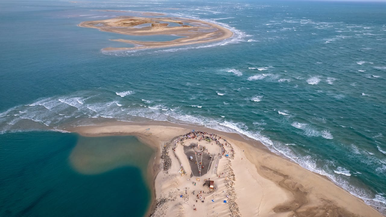
Discover Morocco’s coastline from Tangier to Dakhla through ocean systems, history, and coastal life The Morocco Atlantic coast extends for more than 1,000 kilometers along the western edge of North Africa. It stretches from the Strait of Gibraltar in the north to the desert lagoon systems in the south. This coastline has shaped Morocco’s economic, cultural, and environmental history for centuries. Unlike inland regions, coastal areas developed through interaction with the ocean, maritime trade, and ecological systems. Geographers and historians explain that coastal regions often act as interfaces between land-based societies and global exchange networks. In Morocco, this role appears clearly along the Atlantic shoreline. Ports, fishing settlements, and coastal cities grew in response to ocean conditions, trade routes, and political strategies. The Atlantic coast therefore offers a different perspective on Moroccan identity, one defined by movement, exchange, and adaptation. Geographic Structure and Ocean Systems The Morocco Atlantic coast forms part of the eastern boundary of the Atlantic Ocean. It includes a wide variety of landscapes. Rocky cliffs dominate the northern sections, while sandy beaches and lagoons appear further south. Arid coastal plains emerge as the coastline approaches the Sahara. Oceanographic research highlights the influence of the Canary Current, a cold ocean current that flows southward along the northwest African coast. This current reduces sea surface temperatures and creates nutrient-rich upwelling systems. These systems support marine ecosystems and sustain fishing industries. They also shape climate conditions along the coast. The presence of upwelling explains why the ocean remains relatively cool even in summer. It also explains the abundance of fish species such as sardines and mackerel. These natural conditions influenced where people settled and how they organized economic activity. Historical Development of the Atlantic Coast The Morocco Atlantic coast has long connected inland regions to maritime networks. Archaeological evidence suggests that early populations used natural harbors for navigation and exchange. Phoenician traders and later Roman settlements established points along the coast to facilitate trade. During the Islamic period, coastal towns became part of broader trade systems linking the Sahara, the Mediterranean, and the Atlantic. Goods moved across the desert and reached ports where they could travel further by sea. This created a dynamic relationship between inland routes and coastal markets. From the 15th century onward, European powers established fortified positions along the coast. Portuguese influence appears in several coastal cities. These interventions introduced new architectural forms and defensive structures. In later centuries, coastal cities expanded as commercial ports. Infrastructure development reinforced their economic importance and integrated them into global trade systems. Northern Coastal Cities and Maritime Exchange Tangier occupies a unique geographic position at the meeting point of the Atlantic Ocean and the Mediterranean Sea. This location gave the city a central role in maritime exchange and diplomacy. Its function as a gateway between Europe and Africa shaped its identity. The city developed a diverse urban structure influenced by multiple cultures. Its architecture reflects both local traditions and external influences. The presence of international communities over time reinforced its role as a contact zone between continents. Further south, Rabat combines coastal geography with political autority. The city developed as an administrative center while maintaining a strong connection to the ocean. Its urban organization reflects planned development rather than organic growth. Wide avenues and structured districts contrast with traditional medinas. Coastal fortifications and historical sites demonstrate how rulers used the coastline for defense and control. Rabat’s role as a capital highlights the continued importance of the Atlantic coast in modern governance. Casablanca represents the economic core of the Morocco Atlantic coast. The city developed into the country’s main port and industrial hub. Its growth reflects the integration of Morocco into global economic systems. The port handles large volumes of trade, linking Morocco to international markets. The urban landscape shows modern infrastructure and large-scale development. Casablanca’s characteristics illustrate how coastal cities can transform into economic engines while maintaining their maritime foundations. Central Coast and Planned Port Cities Essaouira offers a different example of coastal development. Founded in 1765 by Sultan Mohammed III, the city was designed as a strategic port. European engineers contributed to its layout, creating a structured grid pattern combined with traditional Moroccan elements. Its role as a trade hub connected inland regions to Atlantic routes. Strong winds, caused by Atlantic atmospheric systems, shape daily life and influence economic activities such as fishing and wind-based sports. The city’s architecture, with fortified walls and open spaces, reflects both defensive needs and commercial functions. Moving south, coastal lagoons and smaller settlements appear. These areas support fishing communities that depend on marine ecosystems. The lagoon systems provide sheltered environments for marine life and human activity. Local economies revolve around fishing, small-scale trade, and resource management. These settlements illustrate how people adapt to specific environmental conditions along the Morocco Atlantic coast. Argan Landscapes and Coastal Adaptation Between Essaouira and Agadir, the coastline intersects with argan tree ecosystems. The argan tree is endemic to Morocco and adapted to semi-arid coastal environments. Its deep root system allows it to survive in dry conditions while stabilizing soil and preventing erosion. Local communities developed agricultural systems around this tree. Argan oil production became an important economic activity. This relationship between environment and human activity shows how coastal regions support unique forms of adaptation. The presence of argan landscapes adds another layer to the diversity of the Morocco Atlantic coast. Southern Transition Morocco Atlantic Coast: From Coastal Plains to Desert Systems Southern Atlantic Coast: From Agadir to the Sahara South of Agadir, the coastline becomes more arid and less densely populated. The landscape shifts gradually from coastal plains to desert environments. Despite these dry conditions on land, the Atlantic Ocean remains highly productive due to strong upwelling systems that support marine life. Sidi Ifni: Colonial Heritage and Coastal Life Sidi Ifni reflects a period of Spanish colonial presence in the 20th century. Its urban layout shows modernist planning with wide streets and administrative buildings. The city acts as a coastal outpost where maritime activity connects with regional governance.
Morocco Imperial Cities: History, Architecture & Powe

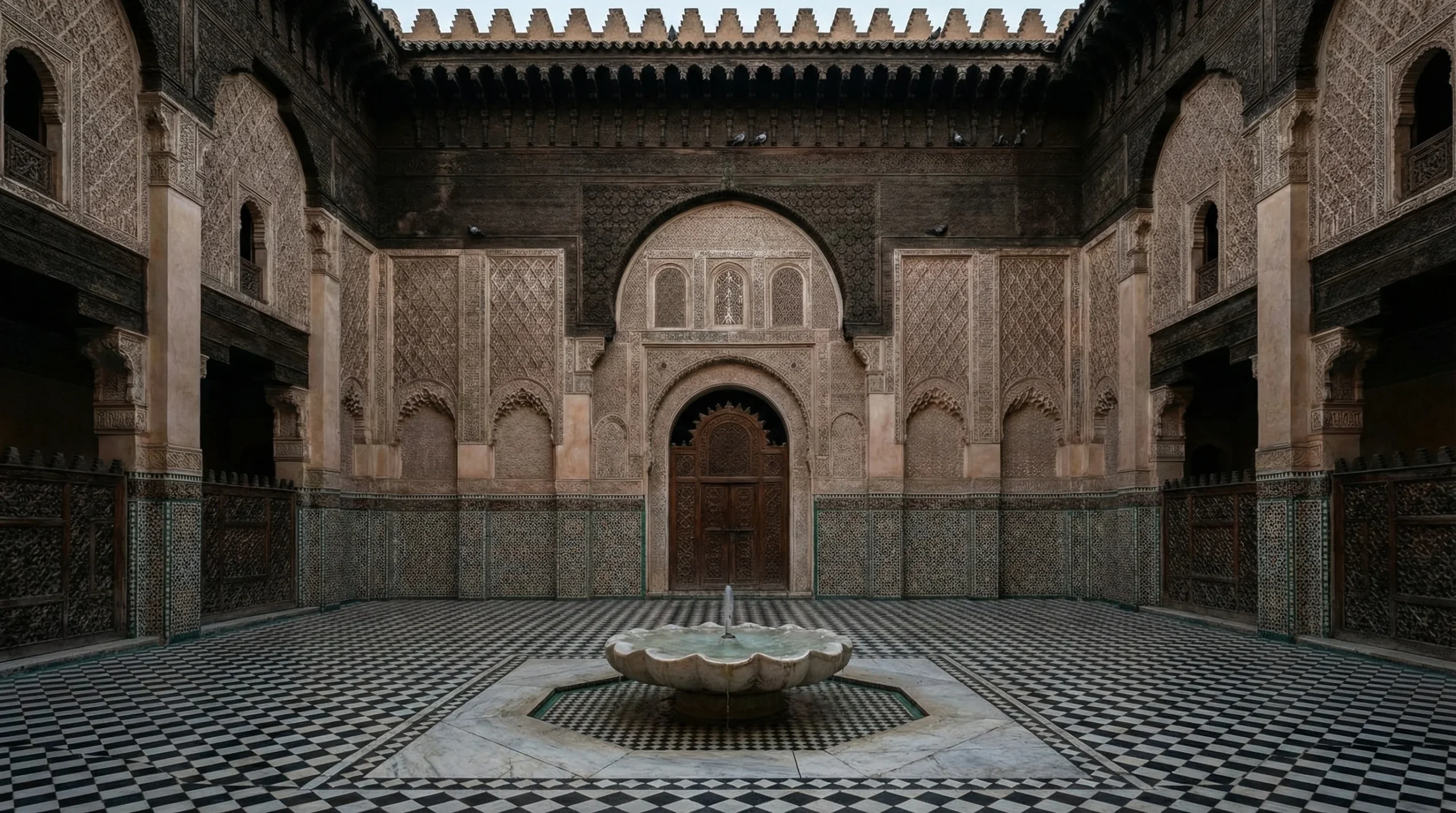
What Are The Morocco Imperial Cities? The Morocco imperial cities form the backbone of the country’s historical and political identity. These cities; Fes, Marrakech, Meknes, and Rabat—served as capitals under different dynasties from the 8th century to modern times. Each city reflects a distinct phase in Moroccan state formation, urban planning, and architectural development. Rulers did not choose these cities randomly. They built them to secure power, control trade, organize religion, and defend territory. Their locations follow strategic routes between mountains, deserts, and coastal plains. Over time, these cities became centers of governance, knowledge, commerce, and military control. This article explores the Morocco imperial cities through historical context, architectural forms, and urban functions, using academic perspectives on how cities evolve under political authority. What Defines the Morocco Imperial Cities? The term “imperial city” refers to cities that served as political capitals under ruling dynasties. Morocco has four: Each city reflects a specific political strategy: Urban historians emphasize that Moroccan imperial cities follow Islamic urban planning principles: Fes – Intellectual, Spiritual and Urban Complexity Founded between 789 and 808, Fes stands as the oldest of the Morocco imperial cities. Idris I and Idris II established it as a political and religious center. Historical Role Fes became the intellectual capital of Morocco. Scholars, jurists, and theologians gathered here. The city hosted one of the earliest universities in the Islamic world, the University of al-Qarawiyyin, founded in 859. Fes controlled trade routes linking: Dynasties such as the Marinids reinforced its role by building madrasas and religious institutions. Architecture Fes developed organically. The medina, Fes el-Bali, remains one of the largest and most complex medieval urban systems. Builders used: Architecture focused on interior space. Houses open inward to courtyards. Streets remain narrow to reduce heat and provide shade. Medina Structure The medina divides into functional zones: This organization reflects a guild-based economic system. Mellah and Royal Protection The Jewish quarter (mellah) in Fes developed later near the royal palace. Authorities placed it there to ensure protection under the Sultan. This proximity also allowed economic interaction between Jewish merchants and royal administration. Characteristics Fes represents knowledge, religion, and continuity. Marrakech – Trade, Power and Monumental Visibility Founded in 1062 by the Almoravids, Marrakech emerged as a strategic capital linking desert trade and northern regions. Historical Role Marrakech became the economic engine of Morocco. It connected trans-Saharan trade routes that transported: Under the Almohads, Marrakech expanded into a political capital controlling parts of North Africa and Al-Andalus. Architecture Marrakech introduced monumental architecture. Builders used: The city earned the name “Red City.” Major structures include: Urban Design Unlike Fes, Marrakech features: The famous Jemaa el-Fnaa developed as a central market and social space. Mellah and Royal Proximity The mellah in Marrakech developed near the royal palace during the Saadian period. Authorities placed it there for protection and administrative control. Jewish communities played key roles in trade and diplomacy. Characteristics Marrakech reflects power through visibility and economic influence. Meknes: Military Authority and Controlled Urban Design Meknes became an imperial capital in the 17th century under Sultan Moulay Ismail (1672–1727). Historical Role Moulay Ismail aimed to centralize authority and create a strong state. He built Meknes as a military and administrative capital. The city housed: Architecture Meknes stands out for its planned urban design. Builders constructed: Materials include: Construction relied on large labor forces and centralized planning. Urban Structure The city separates: This reflects a controlled urban model, unlike the organic layout of Fes. Mellah and Protection System The mellah in Meknes developed close to the palace complex. This ensured security for Jewish communities while maintaining economic links with the royal court. Characteristics Meknes represents discipline, control, and royal power. Rabat: Political Continuity and Modern Governance Founded in the 12th century by the Almohads, Rabat evolved into Morocco’s modern capital. Historical Role The Almohads planned Rabat as a grand imperial capital. Construction slowed after the ruler’s death. The city regained importance under the Alaouites. In 1912, Rabat became the official capital during the French protectorate. It remained the capital after independence. Architecture Rabat combines: Key structures include: Builders used: Urban Characteristics Rabat differs from other imperial cities: Mellah and Urban Integration The mellah in Rabat followed the same principle. It developed near the center of power to ensure protection and economic interaction. Characteristics Rabat represents stability and governance. Mellahs and Royal Protection System Across the Morocco imperial cities, mellahs share a common principle. Authorities placed Jewish quarters near royal palaces. This decision served several purposes: The proximity allowed Jewish communities to: Urban historians view mellahs as part of the political and social structure of imperial cities. Comparing the Morocco Imperial Cities Each city reflects a different function: Together, they form a complete system of governance. Architecture and Materials Across Imperial Cities Common elements include: Techniques: These techniques reflect both environmental adaptation and cultural identity. Why the Morocco Imperial Cities Matter Today The Morocco imperial cities remain active urban centers. They preserve centuries of knowledge about: They also demonstrate how cities evolve while maintaining cultural continuity. The Morocco imperial cities provide a clear narrative of the country’s evolution. Each city reflects a distinct phase of power, culture, and architecture. From the intellectual depth of Fes to the trade-driven expansion of Marrakech, from the military strength of Meknes to the political stability of Rabat, these cities define Morocco. Understanding them means understanding the foundations of Moroccan identity.